https://helloxiaomi.hu/wp-content/cache/breeze-minification/js/breeze_4ffe5168f1dd4fbb3a8549b92ec00c6c.js
https://helloxiaomi.hu/wp-content/cache/breeze-minification/js/breeze_24f337d9f7a0675a54729e53826e30ac.js
https://helloxiaomi.hu/wp-content/cache/breeze-minification/js/breeze_bbcf23329c8c15304414531cb8b73c1f.js
https://helloxiaomi.hu/wp-content/cache/breeze-minification/js/breeze_334768b5a7850e37a581cc353a7a3fe7.js
https://helloxiaomi.hu/wp-content/cache/breeze-minification/js/breeze_e7e8627c354a9621e52780438121bb06.js
https://helloxiaomi.hu/wp-content/cache/breeze-minification/js/breeze_58661d17e4723d674741298eb8472dfa.js
https://helloxiaomi.hu/wp-content/cache/breeze-minification/js/breeze_1f849985ad13e3ba5cbf9a0d1b02185a.js
https://helloxiaomi.hu/wp-content/cache/breeze-minification/js/breeze_437e3eabad30a0a5facfc591cfd2df3d.js
https://helloxiaomi.hu/wp-content/cache/breeze-minification/js/breeze_f9b7aeaa31c02272f31c0f366f42a7b7.js
https://helloxiaomi.hu/wp-content/cache/breeze-minification/js/breeze_f88deeaece1f3f03e1ab08ce8d2c793e.js
https://helloxiaomi.hu/wp-content/cache/breeze-minification/js/breeze_16e39e8801b257e07196f5c4fb07af92.js
https://helloxiaomi.hu/wp-content/cache/breeze-minification/js/breeze_c136ec443a77114d7083b1b75e8b04d8.js
https://helloxiaomi.hu/wp-content/cache/breeze-minification/js/breeze_fe515c1a00d4daabc80c78b4c4e184da.js
https://helloxiaomi.hu/wp-content/cache/breeze-minification/js/breeze_ab447d17071b3c834b3e8f311b8dbfa6.js
https://helloxiaomi.hu/wp-content/cache/breeze-minification/js/breeze_e985f0a3945ec567e2fe79c21efe7bb3.js
https://helloxiaomi.hu/wp-content/cache/breeze-minification/js/breeze_ecc06da3d6cc945830896b77bfbca7aa.js
https://helloxiaomi.hu/wp-content/cache/breeze-minification/js/breeze_30d1dc6f968862584cd536151e59c1c0.js
- Advertisement -
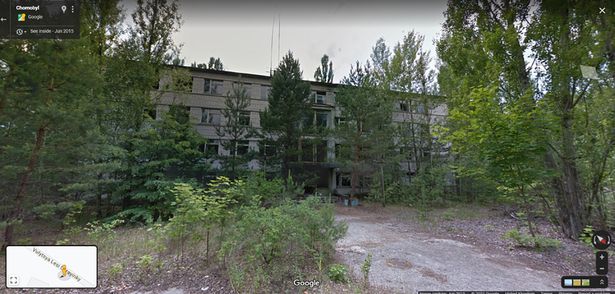
Much to the dismay of Reddit users, the Google Maps street view service is also working in the abandoned ghost town of Chernobyl, Pripyat.
It's not the first and probably not the last time an internet user has come across something strange or scary on the On Google Map . As usual, a conversation about the latest discovery started on Reddit after one poster claimed that the Google Maps street view works in Chernobyl - from a British Daily Star .
Several forum members commented that they had no idea that the ghost town was on Google Maps. Others, however, pointed out that Pripyat, 16 km north of Chernobyl, has become a tourist attraction for disaster tourists in recent years, so it's not surprising that the tech giant's cars have made it to the eerie site.
(Photo: Google Maps) The Chernobyl nuclear power plant accident occurred on 26 April 1986 at the Vladimir Ilyich Lenin nuclear power plant near the Ukrainian cities of Pripyat and Chernobyl. Following one of the world's worst nuclear power plant disasters, large quantities of radioactive material were released into the air, causing the entire population within a 30-kilometre radius of the plant to be evacuated, including the residents of the town of Pripyat.
The number of direct victims of the Chernobyl accident is 31, but the number of people who died as a result of radiation contamination is difficult to estimate, with even the most ingenious research producing figures that vary by orders of magnitude.
- Advertisement -
https://helloxiaomi.hu/wp-content/cache/breeze-minification/js/breeze_269f23bd2de8c3959206567b92f4e976.js
https://helloxiaomi.hu/wp-content/cache/breeze-minification/js/breeze_afc56bbe4844fac6475c28123402d406.js
https://helloxiaomi.hu/wp-content/cache/breeze-minification/js/breeze_374f4a4f41d480afeb5e64248b0ad5ca.js
https://helloxiaomi.hu/wp-content/cache/breeze-minification/js/breeze_71ccde33e74cd4110d9f42cd996414aa.js
https://helloxiaomi.hu/wp-content/cache/breeze-minification/js/breeze_71ccde33e74cd4110d9f42cd996414aa.js
https://helloxiaomi.hu/wp-content/cache/breeze-minification/js/breeze_0f8303f3b7d985ac8b293ed1669d96fd.js
https://helloxiaomi.hu/wp-content/cache/breeze-minification/js/breeze_ed0e746d942f100d312da3ed391823b6.js
https://helloxiaomi.hu/wp-content/cache/breeze-minification/js/breeze_c2db251412d0d673ac32eff41349dd05.js
https://helloxiaomi.hu/wp-content/cache/breeze-minification/js/breeze_3a27d845babc1aad328e35dadf3b0c90.js
https://helloxiaomi.hu/wp-content/cache/breeze-minification/js/breeze_3549936b7ca5bb8597890ab3c2737f25.js
https://helloxiaomi.hu/wp-content/cache/breeze-minification/js/breeze_f1942deecbb0f6b1e122c4d19fd3af03.js
https://helloxiaomi.hu/wp-content/cache/breeze-minification/js/breeze_16156419955a6ecf2480bf9b0d911ab4.js
https://helloxiaomi.hu/wp-content/cache/breeze-minification/js/breeze_f059732b247c75f6f377b2d6e82eada8.js
https://helloxiaomi.hu/wp-content/cache/breeze-minification/js/breeze_7561cb7a6741136aafa3cb5475acb96e.js
https://helloxiaomi.hu/wp-content/cache/breeze-minification/js/breeze_7963dea8a277ff4889fd36e08c00d21d.js
https://helloxiaomi.hu/wp-content/cache/breeze-minification/js/breeze_8c6ad5f2150c505715e730a16d43e654.js
https://helloxiaomi.hu/wp-content/cache/breeze-minification/js/breeze_2897d0c9390b24059cad58bfb37117ae.js
https://helloxiaomi.hu/wp-content/cache/breeze-minification/js/breeze_358b4a2c696e556d85a973f2a974f918.js
https://helloxiaomi.hu/wp-content/cache/breeze-minification/js/breeze_4f8dcd6840c7af34e2a5665e51698be0.js
https://helloxiaomi.hu/wp-content/cache/breeze-minification/js/breeze_47964be3087c6a5b5a8d34ab4f167b14.js
https://helloxiaomi.hu/wp-content/cache/breeze-minification/js/breeze_8f4cdfeb86cf22f23ae24e2b4d7a464e.js
https://helloxiaomi.hu/wp-content/cache/breeze-minification/js/breeze_ea00a7bf639ea5197a80d72da93f78a9.js
https://helloxiaomi.hu/wp-content/cache/breeze-minification/js/breeze_e13ec62235019a03ba10d63b790903f0.js
https://helloxiaomi.hu/wp-content/cache/breeze-minification/js/breeze_b4ab289d9e358c3793d9c8d51041c070.js
https://helloxiaomi.hu/wp-content/cache/breeze-minification/js/breeze_73a21122a1f1375eb5ebbf14100ef4ba.js
https://helloxiaomi.hu/wp-content/cache/breeze-minification/js/breeze_35259b4bb2404fecd4b7d97f42b5e1c9.js
https://helloxiaomi.hu/wp-content/cache/breeze-minification/js/breeze_9413c837d39c256cace6bb458ac45a53.js
https://helloxiaomi.hu/wp-content/cache/breeze-minification/js/breeze_557a7c6532c814f3850c6e81fd11f74c.js
https://helloxiaomi.hu/wp-content/cache/breeze-minification/js/breeze_bd0c04b2199b9007df6d6572374e1399.js
https://helloxiaomi.hu/wp-content/cache/breeze-minification/js/breeze_31a08562719e8f36081df8a60f3506ee.js
https://helloxiaomi.hu/wp-content/cache/breeze-minification/js/breeze_5865f94e09531c642a14979255a65531.js
https://helloxiaomi.hu/wp-content/cache/breeze-minification/js/breeze_0018d5aeeb0c49a8d4604529e45f2ba1.js
https://helloxiaomi.hu/wp-content/cache/breeze-minification/js/breeze_cf6826ebd19d5ec81f3f9ae3fd689522.js
https://helloxiaomi.hu/wp-content/cache/breeze-minification/js/breeze_200e614a2a34b2ab2ec646c1d848eb46.js
https://helloxiaomi.hu/wp-content/cache/breeze-minification/js/breeze_7eb51fed8fbf12bdf74afefc325a109d.js
https://helloxiaomi.hu/wp-content/cache/breeze-minification/js/breeze_bd2c62b121eb756a30007bb4aeb4f94e.js
https://helloxiaomi.hu/wp-content/cache/breeze-minification/js/breeze_7c167bd75d0e1d0433be7a397363cb34.js
https://helloxiaomi.hu/wp-content/cache/breeze-minification/js/breeze_c34c8aafb47e61b8c515bb1c74b59eeb.js
https://helloxiaomi.hu/wp-content/cache/breeze-minification/js/breeze_3bbabe4e2b89c73a10134656916bb7a3.js
https://helloxiaomi.hu/wp-content/cache/breeze-minification/js/breeze_5616af9708e6731b5f768a2c5d032a4d.js
https://helloxiaomi.hu/wp-content/cache/breeze-minification/js/breeze_4efff4685d0437b3940e50aa66855d08.js
https://helloxiaomi.hu/wp-content/cache/breeze-minification/js/breeze_dc2c49dd678ed40c3186e3f58302ce33.js
https://helloxiaomi.hu/wp-content/cache/breeze-minification/js/breeze_8246952e42215bde806ab0da9323aa6a.js
https://helloxiaomi.hu/wp-content/cache/breeze-minification/js/breeze_cd44a12282734e8f9a05f0d5bef6a8c2.js
https://helloxiaomi.hu/wp-content/cache/breeze-minification/js/breeze_5f4444fb3f9aee92feaa63f7cacfb89c.js
https://helloxiaomi.hu/wp-content/cache/breeze-minification/js/breeze_2c03215642da23e74595ea3ddf48d120.js
https://helloxiaomi.hu/wp-content/cache/breeze-minification/js/breeze_d92aab03a41c2170543c8898ae694789.js
https://helloxiaomi.hu/wp-content/cache/breeze-minification/js/breeze_0cb01218d9a8213907c02a4c876c0620.js
https://helloxiaomi.hu/wp-content/cache/breeze-minification/js/breeze_4f48f7205fd0709acf6058cb57ace69d.js
https://helloxiaomi.hu/wp-content/cache/breeze-minification/js/breeze_da89a033488948825fe302561a5b39fc.js
https://helloxiaomi.hu/wp-content/cache/breeze-minification/js/breeze_697fca792199b3925a9c68298ac6aa3d.js
https://helloxiaomi.hu/wp-content/cache/breeze-minification/js/breeze_691d0cdec8f35ac305346231a5729525.js
https://helloxiaomi.hu/wp-content/cache/breeze-minification/js/breeze_0ec21fb6a81f93703128cecdab01f287.js
https://helloxiaomi.hu/wp-content/cache/breeze-minification/js/breeze_f84576f26d234f556954eb66fec2fef8.js
https://helloxiaomi.hu/wp-content/cache/breeze-minification/js/breeze_55b27e89a8c035315534e459d2694d1a.js
https://helloxiaomi.hu/wp-content/cache/breeze-minification/js/breeze_e8ef994e6433edde88f56d1a71e4562c.js
https://helloxiaomi.hu/wp-content/cache/breeze-minification/js/breeze_cfa33c1a683d33e2f4b54df53d2b1da5.js
https://helloxiaomi.hu/wp-content/cache/breeze-minification/js/breeze_d0d15696418c3ba49af209921be705f9.js
https://helloxiaomi.hu/wp-content/cache/breeze-minification/js/breeze_e1bffdcbcdd05e130818c5b19dc4567a.js
https://helloxiaomi.hu/wp-content/cache/breeze-minification/js/breeze_1dd41f6020eec7836753d1602e9e9370.js
https://helloxiaomi.hu/wp-content/cache/breeze-minification/js/breeze_ba3b080762c8d8ec893cd37da7c0395b.js
https://helloxiaomi.hu/wp-content/cache/breeze-minification/js/breeze_3d782c2fced317eebe67174fb21a4f16.js
https://helloxiaomi.hu/wp-content/cache/breeze-minification/js/breeze_3be1cb843622dab49c1d72edfc9bd17e.js
https://helloxiaomi.hu/wp-content/cache/breeze-minification/js/breeze_3a9b5e32fac9388b2cb40a4f4fda5b3d.js
https://helloxiaomi.hu/wp-content/cache/breeze-minification/js/breeze_55d27faa9648d7f3d30df3f791453457.js
https://helloxiaomi.hu/wp-content/cache/breeze-minification/js/breeze_67b66beefe423317068966d0474170f9.js
https://helloxiaomi.hu/wp-content/cache/breeze-minification/js/breeze_bd3679f630043b50da7eb5252b60e088.js
https://helloxiaomi.hu/wp-content/cache/breeze-minification/js/breeze_970ef0d799f04c6f99ee8112a4e70cd4.js
https://helloxiaomi.hu/wp-content/cache/breeze-minification/js/breeze_c4dc1a2e3590d96676f8b7f4b7884d8c.js
https://helloxiaomi.hu/wp-content/cache/breeze-minification/js/breeze_630de2e176b6b918626fe05e3df33451.js


